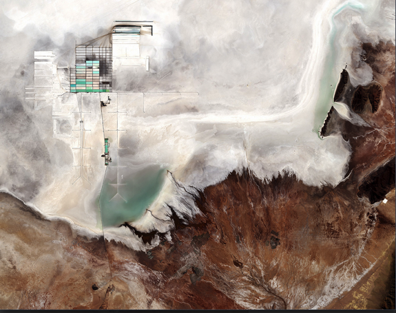
(above) The world's largest salt flat, found in Bolivia, extends for more than 3,861 square miles. This image was captured by the Copernicus Sentiel-2B satellite on May 17, 2017. Credit: Modified Copernicus Sentinel data (2017), processed by ESA, CC BY-SA 3.0 IGO
Satellite Spots Bolivian Salt Plain from Space
July 10, 2017 - www.space.com
By Christine Lunsford, Space.com Contributor
At the south end of the Altiplano plateu in the central Andes, lies Bolivia's Salar de Uynui, captured here in an image from the European Space Agency's Copernicus Sentinel-2B satellite on May 17.
At more than 3,861 square miles (10,000 square kilometers), Uyuni is the largest salt flat on Earth. The area at the southern end of this inland drainage plain was part of a vast prehistoric lake around 40,000 years ago and became the salt flat when the lake evaporated, according to a statement from the European Space Agency.
The local Aymara people have routinely harvested salts from this plain as part of their customs, according to the statement. The plain also contains one of the world's richest lithium deposits that experts estimate at 9 million tonnes.
In the upper left of the image, geometric shapes delineate the large evaporation ponds belonging to the national lithium plant. Here lithium bicarbonate is isolated from the salt brine to be used in manufacturing batteries especially electric-car batteries in recent years.
Terrain surrounding the enormous salt flat is rough. The lower right section of the image reveals the stark difference of the 12.5 mile-wide (20 km-wide) alluvial fan of the Rio Grande de Lípez delta.
Salar de Uyuni is markedly flat, providing variation of its surface elevation of less than 1 meter. The level surface of Uyuni provides a unique and ideal place for calibrating satellite radar altimeters — the radar instrument used to measure surface topography, according to a statement made by representatives of the ESA.